
Construction, Engineering, Real Estate
15 Best Modern Equipment Used in Construction Surveying and Their Uses

Jan
Introduction to Modern Construction Surveying
We use modern construction surveying to guide every stage of a project. Precise field data shapes design, layout, and final delivery. Strong accuracy supports safe work and protects schedule commitments. Digital tools help us measure, map, and verify each key point on site. We trust this data to control structure locations and finished grades. Reliable measurements reduce costly errors and prevent rework. Our teams depend on survey technology to keep every trade aligned. Clear information supports better planning and confident decisions. Modern equipment also improves speed without losing accuracy. This creates steady workflow and consistent project quality from start to finish.
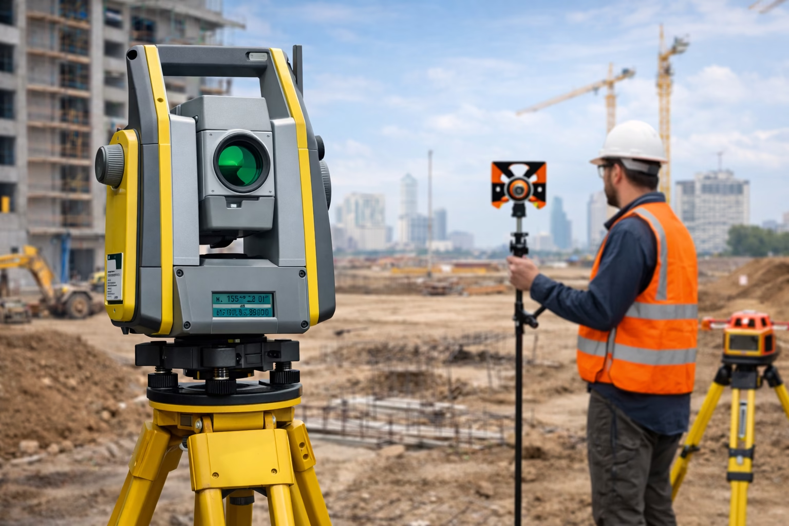
Total Stations for Accurate Field Measurement
A total station is one of the most important tools in construction surveying. It measures both angles and distances with high accuracy. We rely on it to stake out building lines, walls, roads, and utilities. Surveyors set the instrument on a stable tripod and aim at a prism to record each point. The device sends a signal to the prism and receives it back to calculate distance.
We also use total stations to build control networks across the site. These networks act as reference points for every trade. Engineers and contractors depend on this precise data to place foundations, columns, and structural frames. Small errors at this stage can lead to major issues later. The total station helps prevent these mistakes.
Modern total stations store readings in digital form. This removes the need for handwritten notes and reduces human error. Data transfers to office software where we review, process, and archive it. This creates a clear record of layout and verification work.
Total stations perform well in many environments. They remain accurate in both small urban sites and large open projects. With trained crews and regular calibration, these instruments deliver consistent and reliable results.
Robotic Total Stations for One Person Surveys
A robotic total station advances traditional surveying by allowing one trained operator to complete work alone. The instrument locks onto the prism and tracks it automatically as the surveyor moves across the site. This removes the need for a second person to operate the instrument. Productivity improves while labor demands decrease.
We use robotic total stations for layout, line staking, and structural control. The instrument follows the prism smoothly, even over long distances. This tracking feature keeps measurements accurate while reducing setup time. Crews can complete complex layout tasks faster, with fewer interruptions.
Digital control is another key benefit. The surveyor operates the instrument through a handheld controller. Each point is measured and stored instantly. This creates a real time record of all field work. Data flows directly into office software for review and coordination. Clear records support quality control and regulatory documentation.
Robotic systems also lower the risk of human error. Automation reduces manual handling and improves repeatability. When paired with skilled oversight and calibration, these instruments deliver high precision layout. On busy construction sites, this improves alignment, reduces rework, and strengthens overall project efficiency.
Global Navigation Satellite Systems (GNSS) give surveyors the ability to determine real world coordinates anywhere on a project site. GNSS receivers use signals from multiple satellites to calculate precise latitude, longitude, and elevation values. This technology supports large scale work where long baselines and wide coverage are needed.
We rely on GNSS during boundary surveys, route alignment, and large earthwork operations. The system is especially effective in open areas where the receiver has a clear view of the sky. By connecting to correction services, such as RTK networks, we achieve strong positional accuracy suitable for most construction applications. This makes GNSS a dependable tool for both preliminary mapping and final layout tasks.
GNSS improves productivity in the field. Surveyors move freely without needing line of sight between instrument and prism. Fewer setups are required, which reduces time spent resetting equipment. Large sections of land can be mapped quickly and safely. This helps project teams understand site conditions early and plan work with confidence.
Modern GNSS receivers store data digitally for seamless transfer to office software. Engineers and designers use this information to create models, review terrain, and verify construction progress. When combined with other surveying tools, GNSS forms a key part of an integrated measurement system that supports accurate, efficient, and well controlled construction delivery.
Laser Levels for Site and Grade Control
A laser level is essential for maintaining proper elevation and alignment on a construction site. It projects a continuous reference beam that crews use to measure heights and slopes. Surveyors or operators set up the device on a tripod or flat surface, then rotate it to cover the desired area. The laser provides a clear, visible line that acts as a guide for grading, formwork, and foundation layout.
We use laser levels to ensure flat slabs, even drainage, and accurate placement of structural elements. They are particularly useful for concrete pours, road construction, and landscaping where small deviations can cause long-term problems. Crews rely on sensors or rods to read the laser beam and confirm correct elevations.
The simplicity and speed of laser levels make them ideal for daily site checks. They require minimal setup and deliver consistent readings, even on uneven terrain. Durable housings protect the equipment from dust, rain, and rough handling, allowing it to operate in demanding conditions.
Laser levels also improve efficiency by reducing the need for repeated measurements. They provide instant feedback, allowing crews to adjust grading or positioning in real time. This minimizes errors, saves time, and ensures that the project stays aligned with design specifications.
By combining laser levels with other surveying instruments, we achieve precise control over site layout and grades. This integration strengthens accuracy across all trades and supports smooth construction progress from start to finish.
Digital Levels for Precise Elevation Surveys
A digital level is a powerful tool for measuring precise elevations on a construction site. Unlike traditional levels, it reads barcoded staffs to calculate height differences automatically. This reduces human error and improves the speed of field measurements.
We use digital levels to verify benchmarks, check slab heights, and monitor structural movement. They provide highly accurate readings that guide grading, foundation work, and structural alignment. The device records measurements digitally, allowing crews to transfer data directly to office software for review. This creates a clear, organized record of all elevation points.
Digital levels are ideal for both small and large projects. Their precision ensures that slabs, roads, and drainage systems maintain proper slope and alignment. Operators can take repeated measurements without losing accuracy, supporting quality control throughout construction.
The equipment is durable and easy to handle in varied site conditions. Its simple interface allows trained crews to focus on collecting reliable data instead of manual calculations. When combined with other survey tools, digital levels form a critical part of a modern, efficient surveying workflow that maintains accuracy from start to finish.
Accurate elevation data reduces the risk of costly mistakes and supports confident decision making. Using digital levels ensures that every structure sits at the correct height, contributing to long-term durability and project success.
3D Laser Scanners for Detailed Site Models
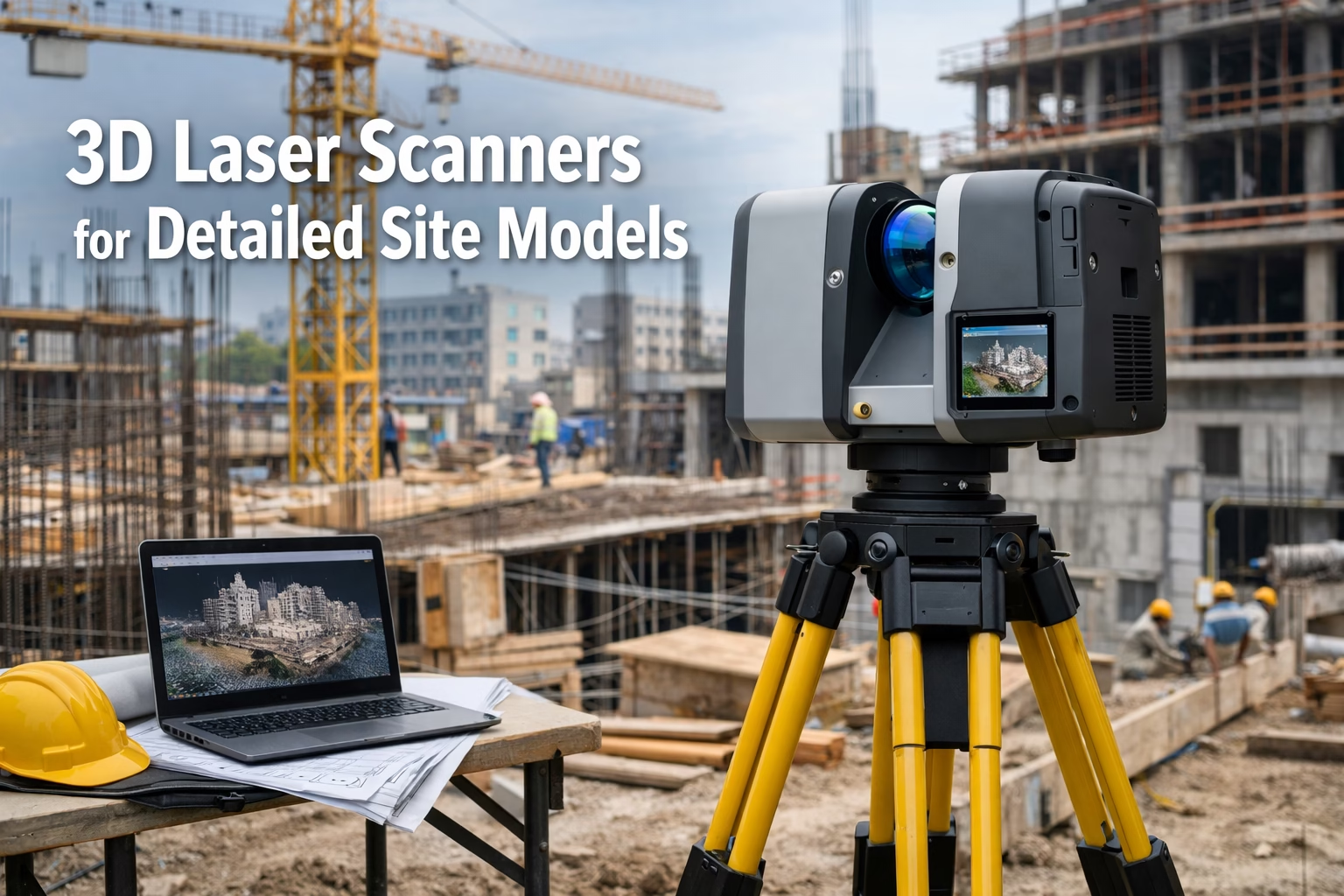
A 3D laser scanner captures detailed measurements across a construction site by recording millions of points. These points form a dense point cloud that represents the exact geometry of buildings, terrain, and structures. Surveyors use this technology to create highly accurate digital models for design, verification, and quality control.
We rely on 3D laser scanners for complex construction projects, renovations, and infrastructure work. The scanner quickly captures data that would take days to measure manually. Every angle, curve, and surface is recorded with precision, allowing engineers to detect potential clashes and alignment issues before construction begins.
The point cloud data is processed in specialized software to generate 3D models, drawings, or as-built documentation. This helps teams compare design plans with the actual site conditions, reducing errors and preventing costly rework. Scanners also support progress tracking, showing how the project evolves over time.
3D laser scanning is particularly useful for areas that are hard to access or hazardous. Surveyors can capture data from a safe distance without interfering with ongoing construction. The equipment is durable and capable of handling outdoor and indoor environments, maintaining accuracy even under challenging conditions.
Integrating 3D laser scanning with other surveying tools like GNSS and total stations enhances workflow efficiency. The combined data provides a comprehensive view of the site, helping project managers, engineers, and contractors make informed decisions. Using 3D scanners ensures that design, construction, and verification processes are precise, streamlined, and reliable.
Unmanned Aerial Vehicles for Aerial Mapping
Unmanned aerial vehicles, or drones, are transforming how we survey construction sites. They capture high-resolution aerial images quickly, covering large areas in a fraction of the time traditional methods require. These images are processed using photogrammetry software to produce accurate maps, topographic models, and 3D site representations.
We use drones to monitor site progress, track earthwork, and verify project layout. They provide a clear overview of the entire site, helping teams spot potential issues early. Drones reduce the need for personnel to access hazardous areas, improving safety and efficiency.
In addition, drones support regular progress reporting. Weekly or daily flights allow project managers to compare current site conditions with design plans. This makes it easier to identify deviations, manage materials, and plan work schedules. The data collected also supports compliance documentation and quality control.
Drones integrate seamlessly with other surveying tools, such as GNSS and total stations. Coordinates captured from aerial imagery can be combined with ground measurements to create highly precise models. This ensures all site data aligns and supports accurate construction decisions.
By reducing field time and increasing visibility, drones improve efficiency and reduce errors. Their ability to capture data in 3D, at scale, and in hard-to-reach areas makes them an indispensable tool for modern construction surveying. Teams can rely on drone surveys for planning, design verification, and progress tracking with unmatched speed and accuracy.
Ground Penetrating Radar for Subsurface Insights
Ground penetrating radar (GPR) is a key tool for exploring what lies below the surface. It sends high-frequency radio waves into the ground and records the reflections from buried objects or changes in material. This allows surveyors to detect utilities, voids, pipes, and structural elements without excavation.
We use GPR before digging, cutting, or drilling to prevent damage and delays. It helps locate underground pipes, electrical lines, and reinforcing steel in concrete. By revealing hidden obstacles, GPR supports safer planning and reduces the risk of costly mistakes.
GPR is effective across a variety of surfaces, including soil, concrete, and asphalt. Operators can scan large areas quickly, creating detailed subsurface maps for engineers and contractors. The data can be exported and analyzed in software to produce clear diagrams and reports.
The technology also aids in condition assessment. We can detect voids, cracks, or degradation under roads and structures. This is critical for maintenance, rehabilitation, and renovation projects. Using GPR improves decision-making and allows teams to plan interventions accurately.
By combining GPR with other surveying equipment, we gain a complete view of the site, above and below ground. This integration enhances safety, efficiency, and accuracy, ensuring that construction proceeds smoothly and without unexpected disruptions.
Electronic Distance Measurement for Reliable Ranges
Electronic distance measurement (EDM) technology allows surveyors to calculate precise distances between points quickly and accurately. It works by sending light or radio waves from the instrument to a target and measuring the time it takes for the signal to return. This provides a fast, repeatable, and highly accurate distance measurement.
We rely on EDM in total stations, handheld devices, and other modern surveying equipment. It supports layout, site control, and structural verification by delivering exact measurements over long ranges. Accurate distance data ensures that building lines, roads, and utilities are placed correctly, reducing the risk of errors and rework.
EDM technology improves productivity in the field. Surveyors can measure multiple points rapidly without physically reaching each location. This reduces labor and allows teams to cover large sites efficiently. The digital readings are stored automatically, enabling seamless transfer to office software for further analysis and planning.
EDM also integrates with angular measurement tools to provide full spatial positioning. This combination allows surveyors to determine exact coordinates in three dimensions. When paired with GNSS or total stations, EDM contributes to a highly precise, reliable, and consistent surveying workflow.
By relying on EDM, we ensure that every measurement is accurate, repeatable, and traceable. This strengthens project control, supports quality assurance, and maintains alignment with design specifications throughout construction.
Data Collectors for Field Information Control
A data collector records measurements in real time. Modern collectors sync with total stations and GNSS receivers. Surveyors review and manage coordinates on the screen. The device organizes files for later transfer into office software. This reduces paperwork and supports clean workflows.
Surveying Tripods and Stable Mounting Systems
Every precise tool needs a stable base. We use strong tripods to support total stations, scanners, and levels. Rigid frames prevent movement during readings. Adjustable legs help crews work on varied terrain. Stability is key when accuracy matters.
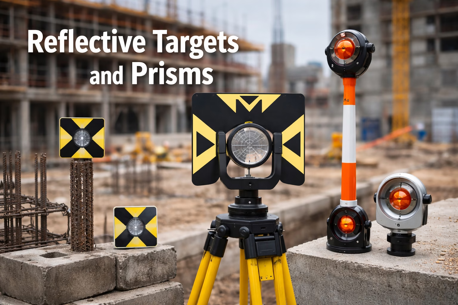
Reflective Targets and Prisms for Line of Sight Surveys
Prisms reflect signals back to total stations. They enable accurate distance and angle measurement. Surveyors mount prisms on poles to mark points. Reflective targets support alignment and tracking. These small tools deliver large gains in precision.
Field Tablets and Rugged Controllers
We often carry rugged tablets to review plans and site models. These devices withstand dust, rain, and impact. Field crews view design data beside measured results. This supports live decisions and quick checks. Real time insight keeps work aligned with specification.
Survey Software for Processing and Quality Control
Office teams use survey software to manage all collected data. We clean, adjust, and analyze the results. The software produces maps, models, and coordinate lists. These outputs guide engineers, contractors, and owners. Strong data control protects the integrity of the project.
Digital Levels of Safety and Compliance
Modern survey equipment supports safer work. Less time near traffic or deep cuts reduces risk. Drones remove the need to climb unstable ground. Automated tools limit manual handling. Accurate information also prevents costly rework.
Training and Skill Support Effective Use
We invest in training to use this equipment well. Skilled surveyors understand both the tools and site conditions. They manage control networks, calibration, and data validation. The mix of human skill and modern tech delivers strong results.
Maintenance Protects Accuracy and Service Life
We maintain each instrument with routine checks and calibration. Clean optics, fresh batteries, and careful storage protect accuracy. A disciplined program extends service life and reduces downtime. This supports project continuity.
Integration with Building Information Models
Survey data feeds directly into building information models. This creates a live link between field and design. Teams track progress and detect issues early. The result is tighter control and better delivery outcomes.
Conclusion on Modern Construction Surveying Equipment
Modern construction surveying equipment is essential for accurate, efficient, and safe project delivery. Tools such as total stations, robotic total stations, GNSS receivers, laser levels, digital levels, 3D laser scanners, drones, and ground penetrating radar provide precise data that guides every stage of construction. Each device plays a specific role, from mapping and layout to verification and quality control. Together, they create a comprehensive system that supports reliable measurements, reduces errors, and improves productivity across all trades.
At Nyolenju Structures, we combine advanced surveying technology with experienced teams to ensure every project meets the highest standards. We help clients plan accurately, monitor progress, and maintain strict quality control throughout construction. Our integration of modern tools and skilled professionals guarantees precision in site layout, structural alignment, and elevation work.
We invite project owners, engineers, and contractors to partner with Nyolenju Structures for professional surveying services. Whether you need precise site layout, topographic mapping, or subsurface detection, our team delivers accurate, timely results that keep your projects on schedule and within budget.
Invest in state-of-the-art surveying solutions to protect your construction investment, enhance safety, and achieve consistent quality. Contact Nyolenju Structures today to learn how our modern surveying equipment and expertise can transform your project.