
Construction, Engineering, Real Estate
Site Surveying 101: Understanding Topography, Soil, and Sunlight

Sep
Introduction to Site Surveying
Every building starts with the land. Before you draw a plan or dig a trench, you must know the site. A site survey gives clear facts about the ground, the shape of the land, and the natural features around it.
Surveying shows where property lines begin and end. It maps slopes, dips, and high points. It reveals where water flows and where soil may hold or shift. These details guide every choice that follows.
A good survey protects your investment. It tells architects how to place a house and plan the foundation. Builders use the data to avoid weak soil and hidden hazards.
Surveying is not guesswork. Professionals use tools like GPS, laser levels, and drones to measure the land with accuracy. Their work ensures that plans match the reality on the ground.
Skipping this step leads to costly mistakes. A house built without proper data can face drainage problems, soil movement, or legal disputes over boundaries.
Site surveying sets the stage for safe and lasting construction. It is the first action that turns an empty lot into a solid home site.
Understanding Topography
Topography shows the natural shape of the land. It records hills, valleys, slopes, and flat areas. A topographic survey gives a clear picture of these changes in height and form.
Knowing the land shape helps you plan where to build. A gentle slope may guide water away from a home. A steep hill may need extra support to prevent soil from sliding.
Surveyors use tools like GPS, drones, and laser levels to measure height and distance. These tools create maps that show every rise and dip with accuracy.
The shape of the land affects drainage. Water always follows the lowest path. If a site has poor drainage, builders may need to add channels or raise the foundation.
Topography also guides road placement and garden design. It helps architects choose where to place windows, patios, and outdoor spaces for the best view.
Ignoring land shape invites trouble. Poor planning can lead to flooding, unstable walls, and costly repairs.
A clear understanding of topography lets builders and designers create homes that fit the land instead of fighting it.
Analyzing Soil Conditions
Soil is the base of every building. Its strength and type decide how a structure will stand. A soil test shows how much weight the ground can safely carry.
Different soils behave in different ways. Sandy soil drains water fast but can shift under pressure. Clay soil holds water and swells when wet, then shrinks when dry. Rocky soil is strong but hard to dig and may need heavy equipment.
Surveyors take soil samples from different spots and depths. These samples go to a lab for tests on strength, moisture, and stability. The results tell engineers what kind of foundation will last.
Weak soil may require deeper footings or reinforced concrete. Strong soil can hold a shallow slab or strip footing. Knowing this early prevents cracks, sinking floors, and costly repairs.
Soil analysis also detects hidden risks like salt, organic matter, or chemicals. These can weaken concrete or corrode metal parts over time.
Builders and designers use this data to match the foundation to the ground. Careful testing protects the structure and the people who will live inside it.
Evaluating Sunlight and Natural Light
Sunlight shapes how a home feels and works. A site survey tracks how the sun moves across the land each day. This shows which areas stay bright and which stay shaded.
Knowing the sun path helps place rooms and windows for comfort and energy savings. Living rooms and patios often face the morning sun for warmth and light. Bedrooms may face cooler directions to stay pleasant in the afternoon.
Surveyors record where shadows fall at different times of year. This prevents dark corners and helps plan for steady daylight inside the home.
Good sunlight cuts the need for electric lights during the day. It also warms rooms in cooler months and lowers heating costs.
Designers use this data to choose roof lines, window sizes, and wall heights. Proper planning keeps glare away while bringing in soft natural light.
Trees and nearby buildings can block or reflect sunlight. A careful survey notes these features so builders can adjust plans before work starts.
Evaluating sunlight ensures a house stays bright, comfortable, and energy smart from the first day of use.
Key Steps in a Site Survey
A site survey gathers the facts that shape every stage of construction. Each step builds a full picture of the land and its features. Here is a deeper look at each step.
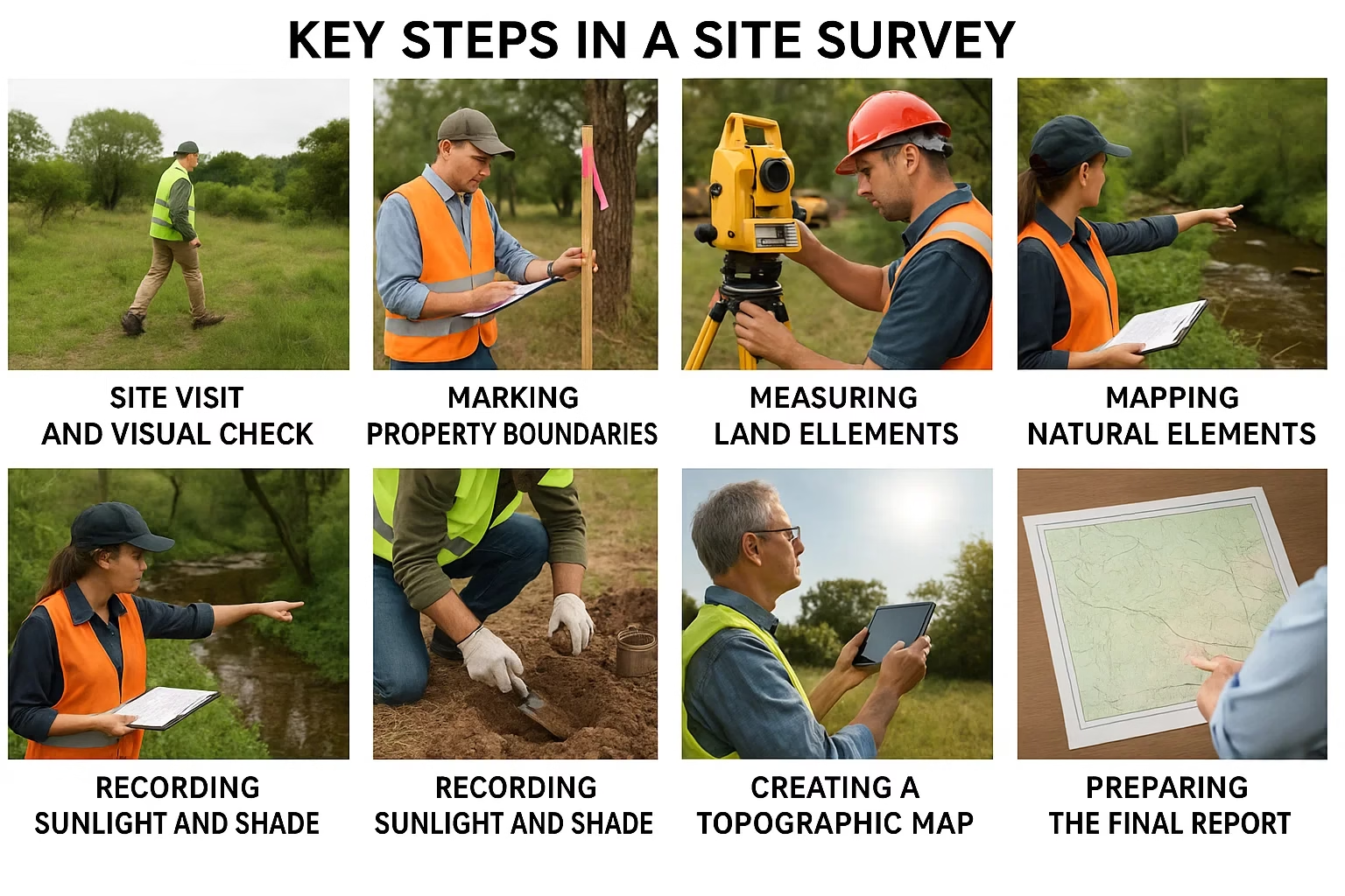
1. Site Visit and Visual Check
The process begins with a walk across the property. Surveyors observe the general landscape, looking for slopes, dips, or areas where water collects. They note natural features like trees, large rocks, and streams that might influence house placement. A visual check often reveals early signs of soil erosion, flooding, or unstable ground that need attention before detailed measurements start.
2. Marking Property Boundaries
Next, the team confirms the exact edges of the land. They review legal land records and compare them with physical markers such as fences, posts, or survey pins. Correct boundary identification prevents disputes with neighbors and ensures the planned building stays within legal limits. This step also highlights any encroachments like neighboring structures that cross property lines.
3. Measuring Land Features
After setting boundaries, surveyors measure the site with precision tools. GPS units, total stations, and laser levels capture the length, width, and height of each section. These measurements reveal slopes, low spots, and elevation changes that affect drainage and foundation design. Accurate measurements create the base for detailed maps and construction drawings.
4. Mapping Natural Elements
Surveyors record the location of natural elements such as trees, boulders, streams, and wetlands. These features can add beauty but also create challenges. For example, a large tree may provide shade but its roots might interfere with foundations or plumbing. Mapping these details helps designers decide whether to preserve, relocate, or remove certain elements.
5. Soil Sampling and Testing
Soil testing is critical for a safe and lasting foundation. Surveyors collect samples from different depths and send them to a lab. Tests check for moisture content, strength, and the presence of clay, sand, or organic material. The results show how much weight the soil can hold and whether special foundations or soil treatments are needed.
6. Recording Sunlight and Shade
Surveyors track the path of the sun across the property during the day. They note where shadows fall at different times and during different seasons. This information helps architects position rooms and windows to capture natural light and reduce energy costs. It also guides landscaping plans, ensuring outdoor spaces remain bright and comfortable.
7. Creating a Topographic Map
All collected data is combined into a detailed topographic map. This map shows property boundaries, elevation changes, slopes, and the location of natural and manmade features. Builders use this map to plan drainage systems, driveways, and the exact placement of the house. It serves as a visual guide for every stage of construction.
8. Preparing the Final Report
The final report gathers all survey findings into one clear document. It includes maps, measurements, soil test results, and sunlight data. Architects and builders use this report to design a house plan that fits the land’s unique conditions. A complete report reduces guesswork, saves time, and ensures a smooth start to construction.
Each of these steps protects the project from unexpected problems. A thorough site survey provides the knowledge needed to design a safe, efficient, and well placed home.
Common Challenges in Site Surveying
Site surveying often reveals problems that can delay or complicate construction. Each challenge requires careful attention and smart solutions. Here is a closer look at the most common issues.
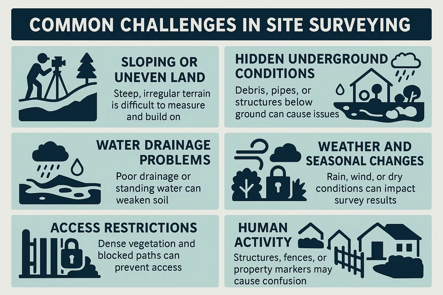
Sloping or Uneven Land
Steep slopes or uneven surfaces are hard to measure and even harder to build on. A sharp incline can cause soil to slide or water to pool in low areas. Surveyors must take extra measurements to capture changes in height and design solutions for safe drainage. Builders may need retaining walls, stepped foundations, or soil stabilization to make the site secure. Early detection of slope problems saves money and prevents future damage.
Hidden Underground Conditions
Not all obstacles are visible from the surface. Rocks, old pipes, buried debris, or abandoned foundations can sit beneath the soil. These hidden features can break equipment, slow excavation, or require unexpected removal. Surveyors use soil probes and historical records to spot underground issues before digging begins. Addressing these surprises early avoids costly delays once construction starts.
Water Drainage Problems
Poor drainage is one of the most serious threats to a new home. Low areas can trap rainwater, weakening soil and causing flooding. Even a slight slope can direct water toward a foundation. Surveyors watch for signs of standing water, damp soil, or natural channels during their inspection. Builders may need to install drainage pipes, raise the foundation, or reshape the land to protect the structure.
Weather and Seasonal Changes
Weather can disrupt survey work and hide key site details. Heavy rain floods low spots and makes soil slippery, while strong winds can affect drone or GPS readings. Dry seasons can mask drainage problems that appear during wet months. Surveyors often schedule follow up visits in different conditions to get accurate data. Careful timing ensures that plans reflect the site’s true year round behavior.
Access Restrictions
Some properties are hard to reach. Dense vegetation, thick brush, locked gates, or nearby construction can block survey equipment. Limited access slows the setup of tools and forces surveyors to take more manual measurements. Clearing paths or arranging permission in advance speeds the process and improves accuracy.
Human Activity
Neighboring structures or past land use can create confusion. Fences, sheds, or driveways may sit on or across property lines. Old survey markers may have shifted or disappeared. Surveyors must compare current measurements with legal land records to confirm true boundaries. Resolving these conflicts early prevents disputes and keeps the project within legal limits.
Each of these challenges demands skill and preparation. A professional survey team can spot risks early, recommend practical fixes, and keep the project moving toward safe and successful construction.
Benefits of Professional Surveying
Professional surveying gives builders and property owners clear facts before construction starts. Accurate data protects investments and prevents mistakes that can cost far more later.
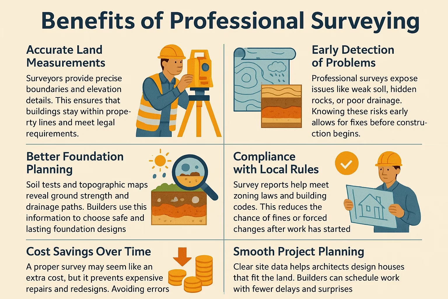
Accurate Land Measurements
Surveyors provide precise boundaries and elevation details. This ensures that buildings stay within property lines and meet legal requirements.
Better Foundation Planning
Soil tests and topographic maps reveal ground strength and drainage paths. Builders use this information to choose safe and lasting foundation designs.
Early Detection of Problems
Professional surveys expose issues like weak soil, hidden rocks, or poor drainage. Knowing these risks early allows for fixes before construction begins.
Compliance with Local Rules
Survey reports help meet zoning laws and building codes. This reduces the chance of fines or forced changes after work has started.
Cost Savings Over Time
A proper survey may seem like an extra cost, but it prevents expensive repairs and redesigns. Avoiding errors saves far more than the survey fee.
Smooth Project Planning
Clear site data helps architects design houses that fit the land. Builders can schedule work with fewer delays and surprises.
Hiring a skilled survey team creates a strong start for any project. Their work gives confidence that the land, the plan, and the construction will come together safely and correctly.
Site Surveying and House Plans
A site survey shapes every detail of a house plan. It turns raw land data into design choices that fit the property. Without this step, even the best plan may fail once construction begins.
Survey results show where to place the house for safety and comfort. Soil strength guides the depth and type of foundation. Topographic maps reveal slopes that affect drainage, driveways, and outdoor spaces. These details prevent costly changes after work starts.
Sunlight readings help designers position windows, patios, and living spaces for natural light and energy savings. A well placed home stays bright during the day and warm during cooler months.
Boundary measurements protect against future disputes. Knowing the exact property lines keeps structures inside legal limits and allows for planned extensions or landscaping.
Nyolenju Structures uses survey data to create house plans that match the unique features of each site. Their team studies soil, sunlight, and elevation to design homes that stand strong and look beautiful.
With a professional survey, a house plan becomes more than a drawing. It becomes a practical guide built on facts about the land, ensuring a home that is safe, efficient, and perfectly placed.
Choosing the Right Surveying Partner
The right surveying partner sets the tone for a smooth project. A skilled team provides accurate data and clear guidance from the very start. Choosing carefully protects your investment and avoids costly surprises.
Look for a company with proven experience. Years of work on different types of land build the skill needed to handle complex sites. Ask for examples of past projects and check client feedback to see how they perform.
Modern equipment matters. Tools like GPS units, drones, and laser levels give precise results and shorten survey time. A team that invests in updated technology delivers faster and more reliable measurements.
Strong communication is essential. Surveyors should explain their findings in plain language. Clear reports help architects and builders turn raw data into practical designs without confusion.
Local knowledge adds value. A company familiar with regional soil types, weather patterns, and building codes can spot issues others might miss. They also know the permits and approvals required to keep your project legal and on schedule.
Nyolenju Structures offers all these strengths. Their team provides detailed remote surveys and custom house plans that match each site. They combine accurate data with creative design to help you build with confidence.
Choosing a trusted partner like Nyolenju Structures ensures your house plan rests on solid facts and a clear understanding of the land.
Conclusion
A strong home begins with a clear understanding of the land. Site surveying reveals the shape of the ground, the strength of the soil, and the path of the sun. These details guide every decision that follows, from the depth of the foundation to the placement of windows and outdoor spaces. Skipping this step risks costly mistakes and unsafe construction.
Professional surveying turns uncertainty into solid facts. It gives builders and homeowners the confidence to design homes that stand firm and last for generations. The right survey protects your investment and ensures your dream home fits the land perfectly.
Nyolenju Structures is ready to help you take this vital first step. Our team provides accurate site surveys and custom house plans designed to match your property. We study your soil, topography, and sunlight so your home stays strong, efficient, and beautiful.
Do not guess when it comes to your future home. Contact Nyolenju Structures today to schedule a site survey and start your house plan with expert guidance. Your land deserves a design built on facts, and we are here to make it happen.
FAQs
1. How long does a site survey take?
Most residential site surveys take one to three days depending on property size and complexity.
2. Can I build on sloping land?
Yes, but it may require special foundation designs and drainage solutions to ensure stability.
3. What is the cost of a site survey?
Costs vary by location and plot size, but professional surveys are a smart investment to prevent expensive construction errors.
4. Do I need a soil test for small projects?
Yes. Even small structures benefit from soil analysis to ensure proper foundation design.
5. How does sunlight orientation affect house plans?
Proper orientation reduces energy costs, improves natural lighting, and enhances indoor comfort.